
I LOVE MAPS.
I’m going to blame this one on The Hobbit and Narnia (my parents read me both when I was pretty little), but I have always loved maps. There’s something really fascinating about maps. I like to know where things are and I also like to imagine what the surrounding environment looks like. It’s all nice and good to know that Mirkwood is a giant forest that Bilbo and the dwarves must travel through, but did you realize how BIG that forest actually is? You need a map for that.
Maps aren’t just for fun. Having an idea of the characters’ environment and where one place is in relation to another is really important—this goes for many genres, but is especially true for fantasy. If you’re creating a fantasy world, you need to know what that world looks like. The fantasy map is a trope, but I personally get a little peeved when I read a fantasy book that doesn’t contain a map. This is a whole new world, I want to know where things are in relation to each other, I want to know what the geography looks like—a visual indicator can go so much farther in that regard than any descriptive passage.
Characters, like people, inhabit space and that space shapes them in a multitude of small ways. Local geography impacts everything from city layout to local cuisine to culture and that, in turn, is going to shape the people who live there. A character from a small desert village will likely have a radically different upbringing from a character who was raised in an urban port city.
If you’re incorporating any kind of journey into your writing, a map can ground that sense of space and distance. This can backfire, of course, especially if the scale and breadth of the world is emphasized again and again and then that emphasis is suddenly taken away. One of the many complaints about Game of Thrones seasons 7 and 8 is that the sense of distance and the size of the world is lost—the characters seemingly teleport from destination to destination, going wherever the plot needs to them go, with no acknowledgement of mundane things such as travel time (thinking of the season 7 finale when an emergency message is sent to Daenerys and somehow, within the time it takes for the runner to run to the location where he can send the message, the raven to fly to deliver the message, and Daenerys to fly 4000 miles north on dragonback, the characters in the emergency situation are still fighting and somehow managed not to die).
Creating fantasy maps, like other aspects of fantasy worldbuilding, is difficult. Most writers probably aren’t geographers and don’t have the scientific background to draft a fully realistic world. But I also think that creating a realistic fantasy world that plays by Earth’s rules is maybe defeating the purpose of having a fantasy world in the first place. Sure it might ruin a reader’s suspension of disbelief to put a jungle directly next to a snowy tundra, but I also don’t think you have to get into the nitty-gritty details of how different regions work. You’re creating a new world. Let it play by its own rules.
(And maybe if there’s a jungle next to a tundra, there’s some strange magic at play, who knows?)
When I start building maps, I think first in shapes. Maps are visual and I think they should be pleasing to the eye. This is a personal pet peeve, but I am not a fan of the Map Blob: one coastline goes straight down or across the map, and then a blob for mountains, a blob for forests, a blob for deserts, etc.
I am not throwing shade, I'm just using these as examples:
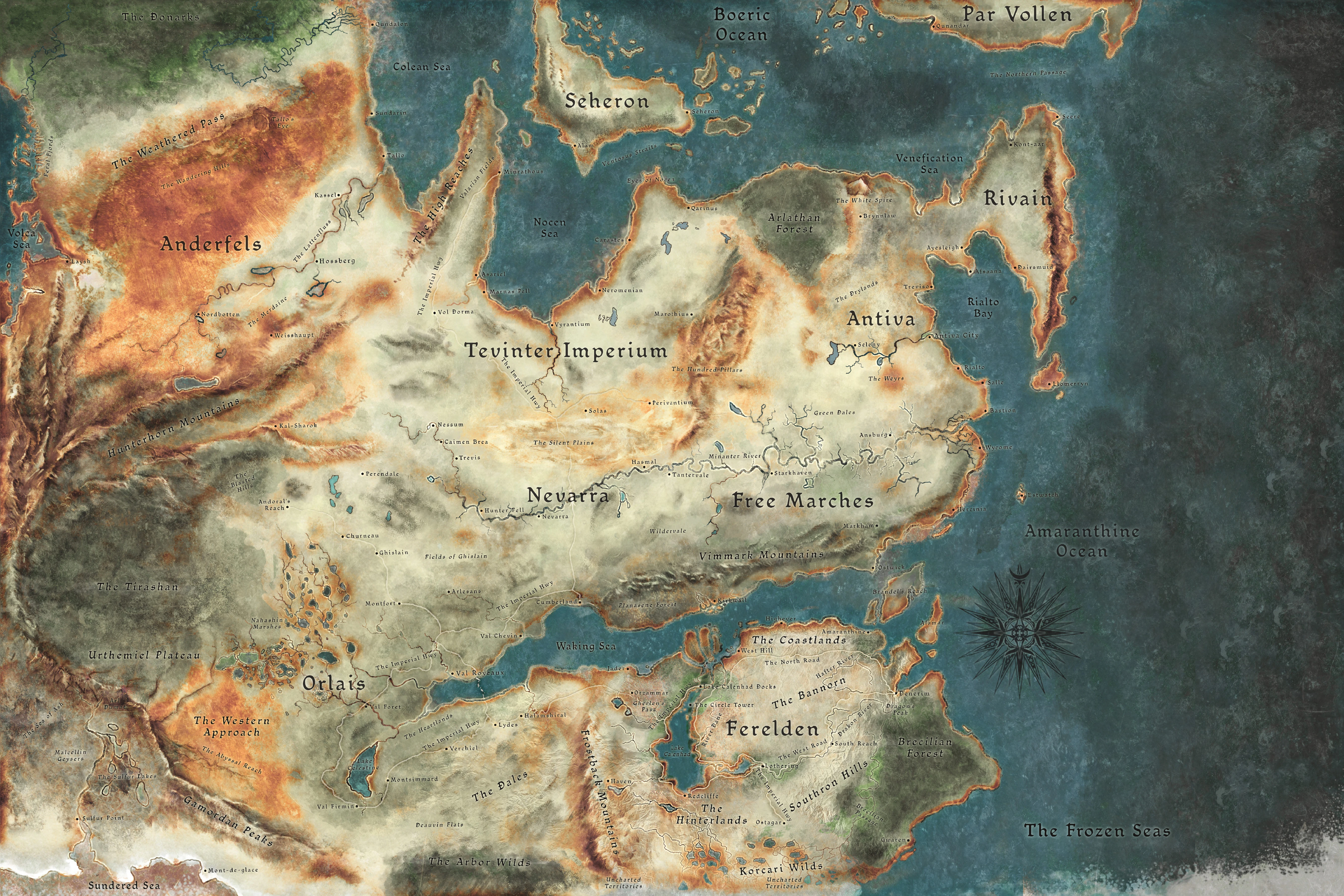
The map in Christopher Paolini’s Inheritance Cycle is like this, as well as the map in Brandon Sanderon’s Elantris (though the geography in that book is tied to the magic system and there are important lore reasons for the world looking the way it does, so it’s a justified map blob). I like the Dragon Age and Middle-earth maps because they’re not reduced to a single coastline, there are clear regions and separate seas that flow out to the ocean.
On the opposite end of the spectrum is the Blob Collection, usually seen in world maps that have multiple continents: random blobs of land across the map, with no rhyme or reason as to how they fit together. The world map of RWBY is like this, but maybe I should give it a pass because Monty Oum made the map out of ketchup smears on an IHOP napkin, which, I mean... valid.
Back on topic. Map shapes.
When I’m starting out, I’ll often look at maps of real-world places that have interesting geography for inspiration, especially for coastlines (I personally think the Norwegian coast is really neat). Once I have all my basic shapes drafted, I’ll figure out mountains, usually by referencing real-world mountain ranges. I’ll look at their proximity to coastlines, deserts, and plains, and then figure out a shape that I think is visually pleasing.
Since most rivers begin in the mountains and then roll down to the ocean, I do rivers next, and then forests. On smaller maps I try not to get too mountain or forest happy. I think it can be very tempting to fill in empty space on your map with mountains and forests, but the map does need room to breathe. I also usually assume that on large world maps, smaller woods and forests don’t need to be placed. If you look at a map of Middle-earth, you assume there are forested areas between the Shire and Rivendell that aren’t on the map, but Mirkwood and Fangorn Forest are marked very prominently as forests.
I’ll often do lakes around the same time as forests. I like incorporating large lakes into my fantasy maps. I grew up in the Great Lakes region of Canada and Lake Huron had such a strong presence in my childhood. The Great Lakes are huge—large enough that you can surf on them on a windy day, large enough that there are hundreds of shipwrecks sitting the bottom because you do not mess with the lakes. Large lakes are really interesting geographical features and I think they’re fun to incorporate.
Once I have all of that figured out, only then will I start thinking about city placement. Cities need access to fresh water, so I’ll look at the rivers and lakes and use their placement to inform where I’m putting major settlements. Most of my capitals go somewhere that would be easily accessible for trade—usually on the coast or on a river that has other settlements on it.
All that being said, here’s the drafting process of Wayfarer’s world map:
The First Draft

I made this in Inkarnate. Already I had a few ideas that have remained the same across iterations:
The Arathian Empire as name goes back to this draft. I was playing Fire Emblem: Three Houses at the time (when am I not playing FE3H, to be honest) and I think I had Adrestian Empire stuck in my head. I wanted something that had a similar sound. One of the countries in my favourite childhood game, Heroes of Might and Magic III, is called Erathia. I think I merged Adrestian and Erathia and got Arathian—and now the name is stuck and I’m not changing it.
Adrasus Citadel was also developed during this draft, as well as many of the city-state names. They were only ever intended to be placeholders (I was drawing from Byzantine city names, as well as ancient Greek, Roman and Macedonian place names—for example, Edessa is an ancient Greek name and was a city in the Seleucid Empire around 305 BC). I frequently use placeholders so I can move onto the next thing and don’t get stuck for days trying to find the perfect name for something—but the trouble with placeholders is that if you use them enough, they eventually just become the name you use.
In this draft, the city-states were countries and I had to name both the country and the capital. Lake Parthia first appeared in this draft (though I would move and rename it later). The country Rona borders was called Melcina, though I hadn’t figure out what kind of geography it has so it was just kind of… chilling there. And, finally, the main setting of the game was called Antheid. Antheid is a placeholder name I pulled from a fantasy novel I wrote in highschool (I never finished it); I knew that name wasn’t going to stick and that I would change it and use it for something else.
The Second Draft

Still working in Inkarnate, except I had a better understanding of the tools so now there’s colour to indicate environment!
I still have country/region names, but I dropped naming the individual capitals/major cities except for Stonehaven as the capital of Reynes and Erenvor as the capital of the Empire. I think Antheid (see how that name moved) became a special city where mages are trained (the concept of the Guild of Mages didn’t exist yet). I also destroyed Melcina and put Rona in Imperial territory, rather than having it on the outskirts/on another continent. I also renamed Farandor as Faro? Why? I don’t know.
The Gairloch Mountains were named in this draft. I don’t remember how I got that name, I think I smushed voice and consonant combinations together until I got something I liked (it’s “gare” (rhymes with stare) “lock” (with the emphasis on lock).
City name change! Antheid is now Stonehaven, which was the working name for when used Wayfarer’s material for a video game writing class. I think this draft was very Dragon Age-inspired. The land shapes, the coastline were all inspired by the Waking Sea. The name Stonehaven was an attempt to find something that had a similar sound and feel to Kirkwall. I renamed Lake Parthia to Lake Ameiran (Ameiran being another name I plucked from my teenaged fantasy novel, though I think I swap back and forth between Ameiran and Ameidan).
The Third Draft

The free-version of Inkarnate, as a web browser-based tool, was getting frustrating to work in so I switched to Wonderdraft, which I still use (it’s a good program!).
This was my first time using Wonderdraft, so I was still unfamiliar with most of its tools. I essentially tried to re-create my earlier Inkarnate drafts, mixing elements from each. You can see me playing around with names (the lake is called Lake Parthia again) and the emphasis on Adrasus Citadel. I also created Mathara in this draft, though it hadn’t become an elven pirate capital yet.
I think this is when I decided Rona was in a wetland and that it was a remnant of Imperial colonialism. Rather than it being on the outskirts of the Empire, it’s a piece that is gone and doing its own thing (like what happened to cities in Roman Britain after the Romans left).
The Fourth Draft

There are a lot of things going on here in this draft. I wanted to have a larger view of the world, to see the layout of some of the places named in the story. So, the continents got named, I started working with most of the placeholders that would become the names of the countries in the current version of Wayfarer. I remember I uploaded the Draft 1 map to Wonderdraft as an overlay and then traced over it to replicate the coastline, and then I edited it back. Wonderdraft has a delightful tool where you can adjust the “roughness” of your land tool—it’s how you can shave off or add onto a coastline and make it look jagged and ragged.
Rhesaina is now the name of the main continent, rather than a region in the Empire. Farandor is Farandor again. I was still sticking with Melcina (the Straits of Melcine is a derivative of that) for the country Rona borders.
The main city is now called Lothryn. I didn’t like Stonehaven, it was always intended to be a placeholder. I got attached to the name Lothryn from my partner, but it had one significant problem:
Lothryn is the name of his D&D bard. Lothryn Blushrose: poet, troubadour, actor, seducer of dragons, and also very likely to get stuck to the sails of a windmill and almost die on his very first session out.
While I did like this draft, I felt it was a little blobby. I liked some of the shapes, but in my attempt to do a full world map, I ended up with something a little “meh”. The central sea straddled between three continents is a little strange. I also had a distance problem: the main setting is supposed to be in the southern hemisphere, but Farandor is a cold country with lots of snow in the winter months. Even if I did put down an equator line, the distance between locations just didn’t make sense for the climate I imagined for each country.
The Fifth Draft
The distance problem and the hemisphere problem needed to be fixed. I essentially needed to flip the map so that the entire thing could be in the southern hemisphere, but I wanted to keep certain shapes intact (particularly Farandor, I like the shapes there). I ended up cutting and uploading different drafts as overlays and tracing coastlines over and over until I was able to find a layout that worked. During this process, I found some new shapes and I also started playing with the idea of the main city being located on a sea that flows into an ocean.


Eventually, I landed on what is the current world map:

Velantis is now Velantis (after a very brief period of being called "Velanis"). Lothryn remains as a reference via the Lotharic Sea. The names of countries/regions in previous maps are now city-states that are part of the Arathian Empire. I named more mountain ranges. I added more citadels to the map, as well as clear indications of Aeda and Melusine settlements. Melcina was dropped as a name as it was too close to Melusine and replaced with Calantha (which I had been using elsewhere). The continents aren’t named on this map because it got too crowded.
Tol Navarre was renamed Tol Covere to avoid confusion with Felix Navorre's last name (I changed his last name from Navarre to Navorre as well). I dropped Kalranthar as a place and stole/moved Sathir (same thing with Osian—it’s a desert now, instead of the name of a city). Rona’s location got moved from the south-east corner of the map to the north-west corner, just as Farandor got moved from north-east to south-west; in many ways, a lot of the geography got reversed. I also added a few new features (namely fleshly out Artanis and the location of the Spire).
I also made a coloured version, but I don’t like it as much (and didn't update this version when I last updated the main one, there's a small edit to the tree line in Calantha):

I would like to make a full global map at some point, but I find those are really hard to make. But I always want to know what’s beyond the borders of a map, so who knows? I may take another stab at it.


